Cape Verde
Things to DO
Santiago
 |
|||||
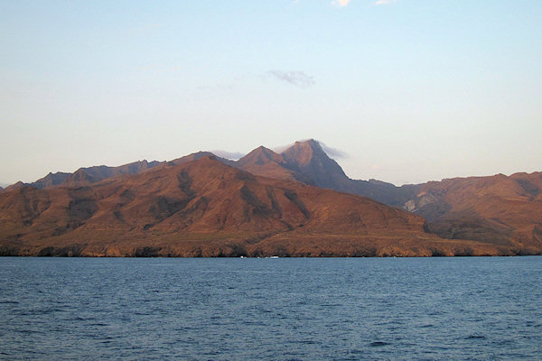
Santiago is the biggest island of de Cape Verde and has had a strong influence on the history of
the archipelago. More than half of the Cape Verdeans now live on this island.
Santiago is probably the most diverse island in terms of its landscape. You can find fine sandy beaches,
mighty mountains and dry steppe areas, as well as fertile valleys and plateaus.
Two volcanic mountain ranges dominate the structure of the island: The arch of the Serra Malagueta
(1394 metres) runs from the West Coast to the East in the North; at the centre of the island, a mountain
range stretches around the island’s highest peak, the Pico d’Antónia.
The achadas (plateaus) in the interior of the island display rich vegetation: Acacia, euphorbias and
figs are very common here since the soil is comparatively moist. In the north and south, the plateaus are
much more barren and crossed by dry valleys (ribeiras).
The island has been very strongly influenced by Africa in terms of its culture. After all, it was the centre
for the slave trade with the neighbouring continent for many years. The classic music styles such as
funana and batuco, are a potent reminder of this fact.
Praia
 |
|||||
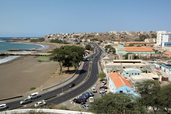
With its roughly 100,000 inhabitants, the capital of Praia pulsates and grows. This is the governmental
and economic epicentre of the country.
But slums that are reminiscent of Brazil‘s favelas and suburbs with multi-storied concrete buildings also
dominate the cityscape.
Praia is busy, loud, hectic -- a typical big city. Businesspeople, diplomats (at home in the Prainha
villa quarter) and the government officials bustle about in the centre, and 10,000 commuters descend
upon the city every day.
The best city beaches are the Praia Prainha or the Quebra Canela, which is close to the Prainha
quarter.
The Praia da Gamboa, is the site of the island’s latest music festival, which takes place once
every year.
The Achada de Santo António quarter, located on a plateau in the west of Praia, is where you will
find bars, restaurants and nightclubs.
It’s also worthwhile to visit the Mercado de Sucupira with its labyrinthine side streets in the
Várzea quarter. This is where you can buy everything from clothing and African fabric to household
appliances to music and traditional handicrafts and the typical national dishes.
 |
|||||
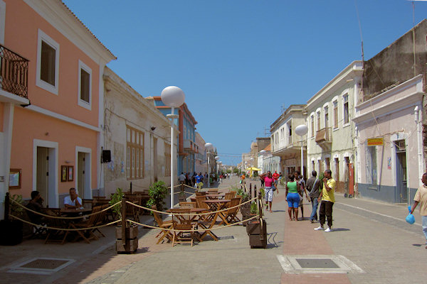
Even if Praia is less tourist-oriented, it still has some attractions for you to discover:
The core of the old town, which is built on a plateau, with its magnificent houses from the colonial era.
Here you can find the Statue of the navigator Diogo Gomes, who discovered the island of Santiago in
1460.
In the centre of the old city lies the Praça Alexandre de Albuquerque.
Around this square lies the City Hall and The Nossa Senhora da Graça church (built in 1900).
Furtheron you can find the food market, the palace of justice, the Museo Ethnográfico, the presidential palace,
and the old town fortress of Bateira, from which you can enjoy a wonderful view of the ocean.
Fogo
 |
|||||
Practically the whole island is an active volcano that has been periodically active, last erupting was
in 1995, forming a new crater called Pico Pequeno.
Its largest feature is a 9 km wide caldera, which has walls 1 km high. The caldera has a breach in its
eastern rim, and a large peak rises in the centre. The central cone forms the highest point of the island and
its summit is about 100 m higher than the surrounding wall of the caldera. Lava from the volcano has reached
the eastern coast of the island within historical times.
A small village, called Chã das Caldeiras, exists within the caldera of the volcano, and the residents
are periodically evacuated during eruptions.
The economy of the island is based on agriculture and fishing, with coffee and wine among the main products.
Brava - Ilhéus do Rombo
 |
|||||
The archipelago's smallest inhabited island Brava is 64km2 and just 10km across at its widest
point.
Much of the coastline is steep cliffs, which rise to a dry central tableland with some mountains rising out
it.
In the west there is a lush valley - Fajã d'Água - with a small, semi-perment stream.
The highest point is monte Fontainhas at 976m, and often swathed in mist.
Ilhéus do Rombo
The islets, located due north at about 7 to 8 km from Brava, contains dry grasslands and rocky coastlines
These islands have been nature reserves since 1990 and are protected by law.
The islets are home for the Cape Verde Shearwater, Bulwer's Petrel and Madeira Storm
Petrel
In these waters the The Pantropical Spotted Dolphin is often seen.
Santa Luzia complex
 |
|||||
The island Santa Luzia plus the surrounding islets Branco and Raso is a
marine-protected area.
Santa Luzia is very dry and barren with a rugged north coast and beaches and dunes to the south.
The highest point is Topona at 395m.
Ilhéu Branco is a large oblong rock rising precipitously from the sea to a height of 327m. It is
one of the major sites for breeding seabirds holding the main breeding population of Cape Verde
Shearwater, as well as breeding populations of White-faced Storm-petrel and the Cape Verde
Little Shearwater.
The Cape Verdean Humpback Whales are believed to be one of the most endangered populations in the
world given the small population size. (about 99 individuals) There breeding ground consists of Cape Verde
but possibly extends to the west African continental shelf of Senegal and Western Sahara.
The pigmentation patterns on the ventral surface of humpback whale flukes are believed to be unique to
individuals.
Raso
 |
|||||
Ilhéu Raso has sheer cliffs, which rise out of the water to a plateau no more than 164m high. It
has the traditional stone plains but also grassy areas.
Raso holds the endemic Raso Lark which is entirely confined to this island with a total population of
45 pairs. The species roams all over the island but breeding is confined to the grassy area in the
south-west.
The island also has seabird colonies with Brown Boobies, Red-billed Tropicbirds,
Madeiran Storm-petrel.
When lucky, you may also find a pair of Osprey.
São Nicolau
 |
|||||
The island, at 343km2, is mainly barren rock with a large semi-humid valley in its centre, cultivated
with maize and beans on the higher slopes, and sugercane and banana below.
In the west is a range of mountains with the highest, Monte Gordo, reaching 1.313m. this peak is
the meeting point of two ranges - one runs north-south and the other out of the northwest.
The eastern finger of land is a long ridge of barren mountains. Between the central mountains and the
western coast are stony plains.
Desertification seems to have hit São Nicolau particulary hard - its orange groves and coffee plantations
have gone and the old folk reminisce about verdent mountainsides that are now bare - in fact the lines of
stone walls that used to devide fields can be traced impossibly high up the mountainsides.
There is evidence of much reafforestation.